Drone and UAV Technology Reviews, Articles, News, Build Logs
New restrictions on drone usage, announced 20 February 2019 by the UK government, are part of a ramp-up of regulatory pressure around the world which could hold back adoption of drone technology, according to GlobalData, a leading data and analytics company.
The company’s latest report, ‘Drones – Thematic Research’ states that the market for the civilian use of drones, both as recreational devices and in commercial applications, has steadily opened up over the last few years. However, regulation is increasingly getting in the way of adoption.
Commenting on the report, Gary Barnett, chief analyst, Technology Thematic Research at GlobalData, said, “The enthusiastic adoption of drone technology by both individuals and enterprises faces regulatory barriers in many countries, driven by a combination of security and safety concerns. However, compelled by industrial demand, several governments are gradually undertaking regulatory reforms relating to the use of drones in commercial airspaces. This, in turn, is fueling investment for technological improvements and business prospects.”
Barnett continues: “As regulations mature, drones as a service (DaaS) providers are poised to take advantage of opportunities to offer industry-specific solutions, with interest growing in a number of domains including drone delivery, drone-based internet services, disaster response, and medical assistance.”
GlobalData predicts that the growing volume of data gathered by drones will also create demand for increasingly sophisticated analysis of that data with artificial intelligence (AI) players such as Microsoft, IBM, Google, and Amazon all gearing up to establish themselves in the drones market.
The Federal Aviation Administration (FAA) posted a rule in the Federal Register requiring small drone owners to display the FAA-issued registration number on an outside surface of the aircraft. Owners and operators may no longer place or write registration numbers in an interior compartment. The rule is effective on February 25. The markings must be in place for any flight after that date.
When the FAA first required registration of small drones in 2015, the agency mandated that the registration marking be readily accessible and maintained in readable condition. The rule granted some flexibility by permitting the marking to be placed in an enclosed compartment, such as a battery case, if it could be accessed without the use of tools.
Subsequently, law enforcement officials and the FAA’s interagency security partners have expressed concerns about the risk a concealed explosive device might pose to first responders upon opening a compartment to find a drone’s registration number. The FAA believes this action will enhance safety and security by allowing a person to view the unique identifier directly without handling the drone.
This interim final rule does not change the original acceptable methods of external marking, nor does it specify a particular external surface on which the registration number must be placed. The requirement is that it can be seen upon visual inspection of the aircraft’s exterior.
The FAA has issued this requirement as an Interim Final Rule—a rule that takes effect while also inviting public comment. The FAA issues interim final rules when delaying implementation of the rule would be impractical, unnecessary, or contrary to the public interest. In this case, the agency has determined the importance of mitigating the risk to first responders outweighs the minimal inconvenience this change may impose on small drone owners, and justifies implementation without a prior public comment period.
The FAA will consider comments from the public on this Interim Final Rule, and will then review any submissions to determine if the provisions of the ultimate Final Rule should be changed. The 30-day comment period will end on March 15, 2019. To submit comments, go to http://www.regulations.gov and search for “RIN 2120-AL32.”
As Transportation Secretary Elaine Chao promised last month, the FAA also posted proposed new rules to let drones fly routinely at night and over people, and to further integrate them safely into the nation’s airspace. The comment period for these proposals is now open and ends on April 15.
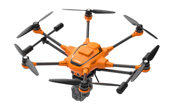
YUNEEC EXPANDS H520 LINE WITH PRECISE RTK SATELLITE NAVIGATION
Real Time Kinematic technology enables users to capture centimeter accurate data
CORONA, Calif. (Jan. 31, 2019) – Yuneec International, a global leader in electric aviation, today announced that its commercial hexacopter, the H520, will now optionally be available with an RTK (Real Time Kinematic) system from the Swiss company Fixposition. Even under difficult GPS conditions, such as in cities or canyons, the RTK system ensures maximum precision and centimeter-precise positioning. The fully integrated RTK satellite navigation enables extremely accurate recurring images, faster 3D mapping and makes automated inspection flights easier and more precise.
The new H520 RTK is perfectly suited for commercial applications that require maximum precision. By using RTK technology, the H520 can now fly much closer to objects for inspection as the UAV positions itself precisely in the centimeter range (1 cm + ppm horizontal / 1.5 cm + ppm vertical) rather than in the meter range, which is standard for the H520. This accuracy is paramount for applications where several images need to be taken at the same location on different days including: documenting progress on construction sites, inspecting mountain landscapes to prevent natural hazards such as rock falls or avalanches, and forensic accident scene reconstruction. In addition, the satellite navigation system makes it possible to significantly reduce image overlaps, which means fewer photos and shorter model calculation times, maximizing efficiency in workflows.
The RTK system is not only fully integrated into the hardware, but also into the UAV’s software. This means the user retains the full range of functions of the award-winning DataPilot™ software at their disposal, including mission flights. The H520 RTK works with two components: the RTK module on board the H520 and a base station on the ground. For precise navigation, the module supports constellations of up to three different satellite systems from GPS, GLONASS, Galileo and BeiDou.
If the use of a ground station is not possible, the system can also be operated with a national reference station network (network RTK). The network RTK is provided by third-party providers and requires an Internet connection, such as a mobile hotspot. All data including satellite data is recorded, which makes the H520 RTK ideal for Post Processed Kinematics (PPK).
The H520 RTK will be available in the second quarter of 2019 in different configurations: as a complete system including the H520 airframe and RTK module, for $3199, and as an upgrade for existing H520 customers for $1699. The H520 RTK GPS ground station will be sold separately for $2399.
-more-
The complete technical data of the Yuneec H520 with RTK system can be found at us.yuneec.com/h520-rtk.
For more information, please visit us.yuneec.com.
About Yuneec International Co. Ltd.
Founded in 1999, Yuneec is a global leader in electric aviation. Its passion for innovation is deeply rooted in the company and is reflected in hundreds of patents. The core technologies of Yuneec include manned aircraft, remote controlled model aircraft and drones for commercial and private use. Yuneec has branches in North America, Europe and Asia, producing over one million products a year for a broad customer base. From the Typhoon series for the enthusiast to the H520 platform for commercial applications, Yuneec continues to innovate, making aerial photography and data collection attainable for every pilot, regardless of previous flight experience.